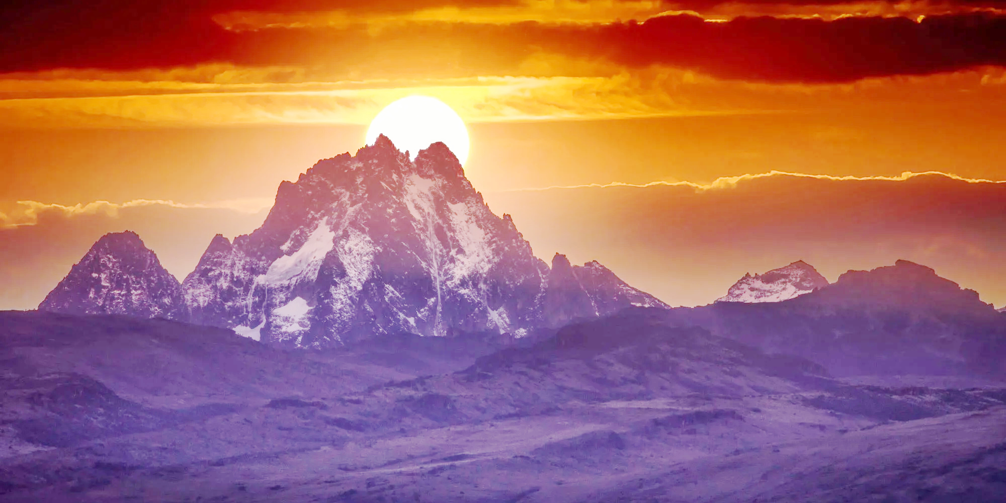
The second-highest peak in Africa, Mount Kenya, soaring at 5,199m (17,058 feet), stands as the loftiest among Kenya's mountainous landscapes. It boasts a roughly circular shape, spanning approximately 60km at the 200mm contour. The steep front hills emerge from the more gradual slopes of the central highlands. At the heart of this massif, the primary summits, including Batian at 5,199m, Nelion at 5,188m, and Point Lenana at 4,985m, sharply rise, creating a spectacular panorama. Additional notable peaks on the mountain encompass Point Piggott at 4,957m, Point Dutton at 4,885m, and Point John at 4,883m. While Point Lenana is accessible to Mount Kenya trekkers, Batian and Nelion pose challenges suitable only for technical climbers.
Despite being the second-highest peak on the continent, Mount Kenya often finds itself overshadowed by its taller counterpart, Kilimanjaro, located about 320km to the south and visible on clear days. Although Kilimanjaro may draw more attention due to its non-technical trekking routes and its status as one of the Seven Summits, Mount Kenya's climbing routes offer a rich array of diverse and exceptional climbing opportunities, encompassing rock, snow, and ice.
The rock quality on Mount Kenya can vary, with the best conditions found higher on the mountain, where the syenite rock resembles granite—rough, hard, and adorned with distinctive features. Beyond the allure of climbing, Mount Kenya captivates with its tarns, alpine meadows, equatorial high-altitude vegetation, and an array of wildlife, including sunbirds, hyrax, and majestic eagles. The circumnavigation of the peaks unfolds as one of the most picturesque expeditions in the East African mountains.
Traversing from cultivated farmlands on the lower slopes through the enchanting rainforest, characterized by diverse tree species, especially camphor, the journey ascends into a bamboo zone, reaching heights of over 12m. The trail continues through open moorland before unveiling the moonscape of the higher slopes. The mountain's ecosystems support a rich diversity of wildlife, from elephants and buffalo in the forests to monkeys and the rock hyrax in the moorlands. Mount Kenya, an ancient volcanic mountain predating Mount Kilimanjaro, once towered above 600m. Erosion has sculpted its remaining form into the intricate and jagged outlines of the central peaks, making it a geological marvel waiting to be explored.
Group trekking Mount Kenya is approximately 200km north of Nairobi, the capital of Kenya, and is comfortably accessible by road using a variety of transport options. These include buses, minibusses, taxi cab or car hire will get you close to the mountain on the tarred roads to the nearest town: Naro Moru town for Naro Moru route, Nanyuki town for Sirimon route and Chogoria town for Chogoria route. Mt Kenya Hiking, Mount Kenya Climbing, Mount Kenya Trekking, and Climbing Africa Mountains. Others are Climbing Mt Kenya, Walking on Mount Kenya, Mount Kenya trekking route, Naro Moru route, Nanyuki, Sirimon route on Mount Kenya, Shiptons Camp. Check below summary of the available private and group trekking routes and prices. The last stretch from the nearest town to the various trailheads (typically +/- 25km) will be on dirt roads and these can be in poor condition (especially in wet weather) and require a 4WD, or an approach on foot.
While Mount Kenya trekking is feasible throughout the year, the period from late March to mid-May experiences the highest rainfall, with a slightly drier spell between late October and mid-December. The forest belt and the southeast side of the mountain receive the most rainfall, reaching up to 2500mm per year at 3000m. Rain and, at higher elevations, snow can be encountered at any time, even during the driest months of January and February. Typically, the drier seasons bring clear, dry weather lasting for several consecutive days. Mornings generally offer the best weather, with any convectional rainfall occurring in the mid-afternoon.
Temperature fluctuations are notable, varying with altitude and time of day. At 3000m, frosts can occur at night, while daytime temperatures range from 5 to 15°C. On the summit, nighttime temperatures fall well below freezing. The south-facing side of Mount Kenya receives more sunshine from December to March, making rock climbs favorable during this period, while snow and ice climbs gradually deteriorate. From June to October, the north-facing rock climbs and south-facing ice climbs are most optimal.
For the safest and most pleasant climbing conditions, the recommended months are during the dry seasons: January to February and August to September. These months offer reliably fine weather, although they may attract more climbers, resulting in busier routes. For those seeking solitude amid slightly less sunny skies, venturing slightly off-peak season is advisable. It's advisable to steer clear of the two rainy seasons, spanning from mid-March to June and late October to December.
Mount Kenya boasts captivating high-altitude alpine vegetation, featuring impressive giant groundsels and lobelias. In the lower-altitude forest zone, trekkers may encounter robust African wildlife such as elephants and buffalo, primarily active during the night. Lions, leopards, rock hyrax, various antelope species, and a diverse array of large and small creatures inhabit the park. Coverage of Mount Kenya's Forest Vegetation in Percentage:
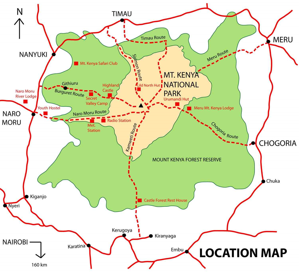
The Sirimon Route offers the most straightforward and picturesque approach to the central peaks on the northern side of Mount Kenya, including Batian, Nelion, and Lenana. Located approximately 15 km from Nanyuki town as you head towards Meru, this route boasts several advantages that enhance its appeal and comfort:
This route provides a comfortable and visually stunning path to explore Mount Kenya's remarkable central peaks.
This route provides access to the mountain's peaks from the eastern side of Mount Kenya. The journey commences in Chogoria town, approximately 96 km from Embu and 64 km from Meru. It is renowned for being the most picturesque route to ascend the mountain, and it owes its creation to the efforts of Ernest Carr, who constructed a vehicle track leading to the moorland during the 1920s. However, it's worth noting that this route is notably longer compared to the other options.
Camping is feasible at the road's end, and a nearby stream offers a readily available water source. Along the route, you'll encounter Mintos Hut, strategically perched at an elevation of 4,300 m on the plateau, offering captivating views of Lake Michaelson, situated 300 m below. For awe-inspiring vistas of the Nithi George, a mere ten-minute walk southeast from Mintos Hut will lead you to the precipice known as the "Temple."
The trail from Hall Tarn leads you onward to Austria Hut at 4,790 m, passing by Square Tarn and the Tooth Col, and then circumventing the head of the Hobley Valley. Alternatively, within a three-hour trek, you can reach Shipton’s Camp at 4,200 m via Simba Col. Descend toward the lower Simba Tarn and make a left turn to arrive at Shipton’s Camp. The Chogoria Route offers an extended yet exceptionally beautiful journey to explore the splendors of Mount Kenya.
This route offers the shortest and most direct path to the peaks, leading you through the Teleki Valley. It's renowned for its popularity among hikers due to its brevity and the clearly defined trail. One distinctive section, known as the Vertical Bog, is particularly challenging, and hikers typically traverse it within two hours after leaving Met Station. This section is characterized by steep, marshy terrain.
After approximately three to four hours of hiking from Met Station, the path ascends to the ridge crest overlooking the Teleki Valley at an altitude of 4,000 meters. Following this crest, the trail contours along the right-hand side of the Teleki Valley, maintaining a higher elevation before gradually descending. Eventually, the path crosses the Naro Moru stream en route to Mackinder’s Camp, situated at 4,200 meters.
The hike from Met Station to Mackinder’s Camp typically spans about 5 to 6 hours. From Mackinder's Camp, it takes an additional 4 hours of walking to reach the Austrian Hut. Afterward, in just 45 minutes, you'll arrive at Point Lenana, standing at an elevation of 4,985 meters.
The Burguret route commences at the Mountain Rock Hotel and proceeds through the forest, passing by the Gathiuru Forest Station, until it reaches a less defined roadhead situated at an elevation of 2,500 meters within the plantation area. Continuing from this point, the trail leads to Elephant Camp at 2,600 meters. As hikers advance, the path traverses through a tropical rainforest, gradually transitioning into the more open Hagenia-Hypericum Zone at approximately 2,860 meters. Eventually, you'll enter the Heath Zone, offering clear vistas of the mountain's prominent peaks.
Beyond this, hikers will encounter a suitable campsite known as 'Campi ya Farasi,' where tents can be set up for an overnight stay. Departing from 'Campi ya Farasi,' the trail veers left and embarks on a steep ascent out of the valley. The ridge will take a rightward turn once again, guiding you across rocky terrain around the hill. Subsequently, the path curves to the left, leading via the Hausberg Col and Oblong Tarn before reaching Mackinder's Valley. From there, it descends to Shipton's Camp, positioned at an elevation of 4,200 meters.
Starting from Shipton’s Camp, you'll begin your ascent directly to Kami Hut. From there, you'll follow a path across sandy scree to reach Hausberg Col before descending steeply to Oblong and Hausberg Tarns, where you can take a brief rest. After your rest, the trail proceeds directly between the two tarns, leading you to the base of a scree slope that climbs steeply to a col with Nanyuki Tarn at its base. From this col, the path trends left and descends, passing below Arthur's Seat. It continues to reach Nanyuki Tarn, passing to the left of the tarn, ascending a short rocky section, and crossing a small col to reach Hut Tarn. From Hut Tarn, you'll turn right to arrive at Two Tarn Hut, situated at an elevation of 4,490 meters.
Continuing on, the path follows the right side of the tarn, climbing a boulder-strewn area to reach a scree slope that overlooks Teleki Valley. It then descends through a steep scree slope, eventually reaching Mackinder Camp at 4,200 meters.
From Mackinder’s Camp, you'll head northward to meet a trail coming from American Camp. On the opposite side of the valley, you'll spot the path leading to Austrian Hut, marked by clear cairns. Follow this path as it winds around the head of the valley, crossing boulder scree and a substantial buttress. The trail then trends steeply upward, eventually reaching Tooth Col. From this col, you'll have a vantage point to look down into Georges Valley and observe Hall Tarns.
The path then descends to Square Tarn, continuing to follow cairns as it trends left and descends toward Simba Tarn. After a steep descent to the lower Simba Tarn, you'll cross over to return to Shipton’s Camp. The estimated hiking time to complete the entire circuit is approximately eleven hours. It is advisable to divide the trip into two days by spending a night at Mackinder’s Camp in the Teleki Valley at an elevation of 4,200 meters.
Throughout the hike, it's crucial to adhere to established trails whenever they are present to protect the surrounding vegetation and prevent soil erosion. In areas without designated trails, make sure to spread your impact by avoiding single-file hiking to prevent the creation of new trails. During breaks, choose resting spots that won't leave visible signs of human presence, such as rocky or bare ground. Avoid sitting on vegetation to preserve it. Main Peaks of Mount Kenya: Mt Kenya elevation:
Glaciers on Mount Kenya are retreating rapidly. The Mountain Club of Kenya in Nairobi has photographs showing the mountain when it was first climbed in 1899. Again more recently, and the retreat of the glaciers is very evident. Descriptions of ascents of several of the peaks advise on the use of crampons, but now there is no ice to be found. There is no new snow to be found. Even on the Lewis Glacier (the largest of them) in winter, so no new ice will be formed. It is predicted to be less than 30 years before there is no more ice on Mount Kenya, climbing & trekking Mt Kenya.
The area of glaciers on the mountain was measured in the 1980s and recorded as about 0.7 km² (0.25 square miles). This is far smaller than the first observations, made in the 1890s.
Mount Kenya is the main water catchment area for two large rivers in Kenya. The two are the Tana River, the largest river in Kenya, and the Ewaso Ng'iro North. The Mount Kenya ecosystem provides water directly for over 2 million people. The streams that start on Mount Kenya are:
Mount Kenya climbing Information, Mount Kenya facts, trek Mount Kenya joining dates Mt Kenya climbing itineraries, Mt Kenya Climbing Gears, Mount Kilimanjaro Climbing Needs, Mount Kenya porters, Climb Mount Kenya, Mount Kenya group hikes, Mount Kenya Guides, Climb Mt. Kenya, Climbing Mt Kenya Routes, What you need while hiking Mt Kenya Climb and check out facts about Mount Kenya and history and Mount Kenya climbing routes explained.
Here is a list of travel information you may find useful when planning your safari holiday tour of Kenya and Tanzania. If you require any further details or have questions on something not covered by this list, please get in touch with the Grayton Expeditions team.

Tourists visiting Kenya must have a valid visa. Your passport must also be valid for at least six months after the date
Read More
At Grayton Expeditions, we embrace hospitality as a way of life, treating every guest as more than just a traveler but as a cherished friend. The concept of a safari takes on a new depth as we meticulously consider every detail...Read More